
Search Bay City Streets by Address
Begin an address-based Bay City street directory search with the land record rather than a name list. Bay County FetchGIS can locate a parcel by street address, owner, PIN, intersection, or coordinates. The resulting report establishes the parcel and property address. From there, a recorder search connects the listed owner or legal description to recorded instruments. Election records and historic street sections have different rules and should be used as separate confirmation, not assumed from the parcel result.
A full named street requires repeating this process parcel by parcel. A block can contain corner parcels, rear parcels, multiple units, trusts, business owners, and newer or older numbering patterns. Keep a research log with the street number, PIN, current property address, listed owner address, legal description, and record date. That makes it possible to check a later mismatch instead of blending results from two nearby parcels.
- Enter the street number and name in FetchGIS, trying a spelling variant, no unit number, an intersection, or map browse if the address does not resolve.
- Open the parcel report and record the PIN, property address, owner address, and legal or tax description.
- Use the owner as grantee in the Register of Deeds index, then compare the deed's legal description to the selected parcel.
- For a lawful voter-file question, use the public request process and retain its redaction and date limits.
- For an older address trail, check Polk street sections or a verified criss-cross volume at the library.
Bay City FetchGIS Searches Streets
The Bay County and Bay City FetchGIS viewer is the central street tool because it is built around mapped parcels. County training describes a 14-digit PIN search, owner-name results, street-address searching, intersection search, and coordinate search. A street query may be sensitive to spelling and capitalization. If a number and street fail, look for a directional version, a shortened street type, a nearby intersection, or the parcel polygon on the map.
Once a target parcel is open, the map can be used to browse nearby polygons. Its tools include property reports, basemaps, layer controls, buffer selection, measurements, printable reports, saved CSV output, and labels. That does not transform FetchGIS into a person directory. It is a spatial property system, so the useful output is a bounded set of parcels and county report fields that can be checked through the right record custodian.
| Bay City FetchGIS field | Type | Use by street |
|---|---|---|
| Parcel ID or PIN | Text or grouped input | Links a known county parcel to the map report. |
| Owner Name | Text | Returns a list of parcels associated with a listed owner. |
| Street Address | Text | Accepts a number or name, subject to spelling and case quirks. |
| First and Second Street | Text pair | Finds a crossing when an exact number is not known. |
| Buffer target and size | Selection controls | Selects a spatial group of parcels for map research. |
Bay City Parcel Reports Separate Roles
The FetchGIS report visibly keeps Property Address and Owner Address apart. Property address, sometimes called situs, is the place where the land or building sits. Owner address is the tax-roll contact line. The two may match, but a different mailing line can point to a post-office box, a business, a trustee, an agent, or another residence. A listed owner is also not proof that every occupant at the property is named in public records.
The same report can include acreage, zoning, frontage, depth, land value, tax description, sales information, building year and characteristics, tax history, and delinquent-tax information. Those details help confirm that a deed or permit belongs to the correct parcel. A homestead-related field may support an inference only when the live record actually shows it. It should never substitute for a direct current-residence record. The county's GIS disclaimer is clear that the map is informational, not a legal survey or official county record.
- PIN
- The county parcel identifier, documented in FetchGIS training as a 14-digit number.
- Situs address
- The property location, distinct from a tax-notice mailing address.
- Plat
- A recorded map that can connect a lot, block, subdivision, and street location.
- Criss-cross directory
- An address-first volume that may show a listed head of household or business.
Bay City Deed Chains Follow Parcels
For a given Bay City address question, the deed trail begins after the parcel is identified. Search the current listed owner as a grantee in the Landmark or Doxpop system. The acquisition instrument can identify a prior grantor. Search that prior party as a grantee to find the earlier acquisition, then repeat while comparing the same legal description, lot or block, document date, and parcel context. A surname match alone is not enough for a sound address history.
Bay County uses several research layers. Its online card index expressly covers 1958 through 1984. The newer Landmark page exposes party, document, town, date, book and page, case, clerk-file, and legal search modes. Doxpop is county-linked for around-the-clock land-record searching, though the research did not capture its dynamic live fields. For years that cannot be resolved online, the Register of Deeds counter can help locate deed books, card materials, plats, grantor-grantee ledgers, and other archival paths.
The Bay County Landmark Web recording index shows the documented search modes and controls used to narrow a deed or other recorded instrument.
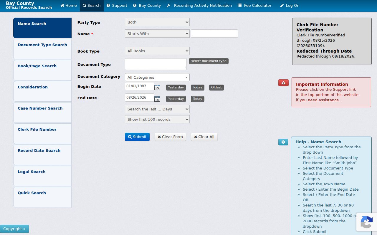
Use an index result to locate the precise record reference, then confirm the address trail against the deed's party role and legal description.
Bay City Street Records by Custodian
Each address-based source answers a different question. A parcel report names a listed owner and maps the land. The deed index records parties and document references. A permit can show a project or named applicant. A voter-file request is governed by state disclosure rules. The historical directory shelf can place a listed household in a year. Combining them carefully produces a stronger address result than repeating the same address in one system.
| Address record | Bay City keeper | What it can show | Access channel |
|---|---|---|---|
| Parcel and tax record | Equalization and GIS | Listed owner, property and owner addresses, values, map context | FetchGIS, county property query, counter |
| Recorded document | Register of Deeds | Parties, date, legal description, deed or lien reference | Landmark, Doxpop, card index, research desk |
| Voter-file material | Election officials | Permitted public registration fields with redactions | Lawful written QVF request |
| Permit or code file | City Building and Code Enforcement | Address, work or complaint dates, and file-specific named parties | Forms, department contact, focused records request |
| Historical street section | Bay County Library and historical collections | Dated address and listed household or business clues | Library database, shelves, or research assistance |
Note: County property data is ownership and parcel evidence, not a complete roll of every person connected to a street address.
Bay City Documents Use Two Citations
Bay County's January 1, 2018 citation change is an important practical detail. Older recorded documents may be cited by Liber and Page, while documents after that date use a Document Number. A searcher who has one kind of reference should not assume the other field will return the same result. Carry both the old citation and the newer document number when a chain crosses the changeover.
The 1958-1984 card index is another separate layer. It can close a useful gap between a modern search and an older paper trail, but it should not be mistaken for continuous online coverage before or after those dates. In December 2025 the county approved a three-year Common Chain project intended to improve archived deed indexing back to 1857. That target signals future work, not a completed claim that every historical instrument can already be searched from home.
Bay City Permits Add Street Dates
City of Bay City permit and code records can add a date layer to a street search. The city lists building, demolition, electrical, mechanical, plumbing, sign, soil-erosion, and engineering forms. A permit packet may contain a property address, the kind of work, applicant or contractor details, fee, and inspection history. The city requires the forms to be completed and returned, and it did not provide a searchable historic permit database in the reviewed sources.
Code Enforcement handles address-based nuisance and land-use matters such as debris, disabled vehicles, yard waste, parking, signage, dumping, and other exterior conditions. Its files are not a resident roll, and what a particular file releases depends on the record and applicable exemptions. Ask for a narrow address, office, record type, and date range. For older work, request the building, electrical, plumbing or mechanical file, permit card, inspection dates, and any available owner or applicant field rather than asking an office to create a new summary.
Bay City Street Directories Preserve Names
Before modern parcel viewers, street sections in Polk directories placed streets alphabetically and entries in house-number order. Bay County Library's searchable Bay City directory database covers 1873 through 1946, and the Bay County Historical Society reports Polk material reaching to 1866. A Polk surname entry can also add occupation, household references, residence, and abbreviation clues. These volumes are dated snapshots and need support from deeds, maps, census schedules, newspapers, or vital records.
Library of Michigan guidance describes later Bresser or criss-cross volumes as street-first sources with listed heads of household, phone numbers, and movement indicators. The exact Bay City run has not been confirmed, so request a specific volume before relying on that format. The Bay City city directory collection page explains the historical shelf in depth; for a modern street-by-street question, return to the parcel and deed chain after the historical lead is found.
Bay City Streets Cross Old Place Names
A missing address can be a naming problem rather than a missing record. Bay County history says Lower Saginaw became Bay City in 1857. Historic directories use Bay City alongside West Bay City, Wenona, Portsmouth, and Salzburg. Search each reasonable place-name form in an old directory or map, and compare street section, lot or block, and legal description before deciding two entries refer to different locations.
Modern maps and postal routes add another layer. A Bay City mailing address can extend beyond municipal limits, and the county did not document a verified citywide readdressing schedule. Do not invent a number conversion. Instead, use plats, Sanborn maps, directories, and the current GIS parcel record to bridge a change in wording or numbering. This is especially important when a deed uses a lot and block but a directory uses only a street number.
Bay City Street Directory Limits
A street search can identify mapped parcels, listed tax owners, recorded parties, historic directory entries, and certain file-specific public information. It cannot reliably identify every private occupant on a street. Utility accounts, delivery records, motor-vehicle personal information, protected voter applications, sealed court or vital files, and people omitted from historical directories are not part of an open address list. Michigan's Address Confidentiality Program can substitute an eligible participant's address in government use.
Commercial neighbor-search categories can combine old address extracts and public-source data, but they can be stale, duplicate a same-name person, or omit context. County and state records make it possible to check the source, date, and custodian. A corrected parcel, docket, voter, or vital record must be addressed with the office that maintains it. It cannot be fixed simply by changing a third-party profile.